
Leibniz Institute Goes High Tech for Testing Soil Conditions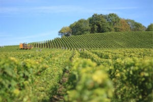
*Adapted from ‘Guaranteeing Yields’ from Delphin Technology.
Delphin Technology provided The Leibniz Institute of Vegetable and Ornamental Crops (LIVO) with a custom data acquisition system for use in agricultural soil testing and mapping soil conditions in agricultural fields. The measurement system has been developed as part of the institute’s research aimed at establishing a scientific basis for efficient horticulture methods in sustainable farming.
Seventy-five years ago, Germany divided its agricultural land into 50 × 50-meter plots. Then soil samples were taken, analyzed and the data mapped. Today, farmers rely on this information to help guide their activities. However, modern measurement techniques now exist to deliver more accurate information which enables farmers to treat the land in a way that ensures a more ecologically friendly and efficient agriculture according to Dr. Jörg Rühlmann, of the institute.
Dr. Rühlmann explains: “Truly efficient farming needs to not only match local conditions but also has to take into account the variable properties within the soil across each section of land. This allows us to optimize the use of fertilizers, irrigation systems, sowing methods, and tillage depths.”
Seeing Beneath the Soil
Test fields are surrounded by a lush expanse of meadows, crops, and woodlands just south of Berlin where a mobile, rolling system of electrodes patrols beneath the soil to measure conductivity. This innovative measurement system is named “Geophilus Electricus” after a species of centipede, like its namesake the system is shaped similarly and is able to ‘see’ into the soil.
 The Geophilus Electricus sensor array is designed to measure bulk resistivity in the soil where variations in texture, water content, grain size, salt content, temperature, and stratification determine electrical characteristics such as amplitude and phase. This is a joint project between the Leibniz Institute, Potsdam University, and Delphin Technology.
“Geophilus enables us to map soil variations over small areas and to optimize the use of fertilizers, water, seeds, and fuel,” says Dr. Rühlmann. Six pairs of rolling metal electrodes mounted in a row are electrically isolated from one another to form the sensor. The first pair feeds current into the soil and the remaining five measure potential voltages in the soil at five different depths. The greater the distance between the feed and the potential electrode, the deeper the view into the soil. Currently, the system can be deployed to a depth of 2 meters.
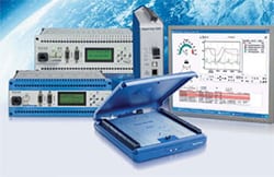
The team needed hardware and software for agricultural soil measurements and 3D maps. They chose Delphin Technology for data logging because they are a leading supplier in Germany and offer flexible development services. Dr. Rühlmann explained that their systems are based on standard equipment, not specialized components. The Delphin Expert Logger device and ProfiSignal Software were chosen for use in this application. “The hardware, firmware, and software interfaces can be varied according to our needs and therefore adapted to exactly what we want, including personalized documentation of data and results,” said the project leader. Ongoing technical developments can be integrated including those to the Geophilus sensor array, “A major benefit of the system is it’s expandable because additional sensors are easy to integrate into the measurement system.”
The system must be robust and resistant to weather, and shocks, capable of independent operation, and able to transmit data via WLAN. Furthermore, the system must be able to acquire and record GPS data and other measurement data from the specific measuring points. All while being as compact as possible.
Another important factor was measurement speed. Results need to be observable while recording is taking place, and fast mapping is also necessary. The Delphin system also provides an export function to Google Earth, enabling a convenient way for users to visualize the data.
Single Mapping for Multiple Gains
Agricultural soil mapping only needs to take place once to improve yields. Farmers then benefit year after year because they no longer have to farm a field as one unit but are working the land according to management zones. Zones are individually farmed by loading the maps into the on-board computers in farming equipment where GPS connectivity is established. Dr. Rühlmann sums up the premise; “Precision farming means achieving an optimal compromise between high quality and quantity yields, minimal environmental contamination, sustainability, and profit.”
The project has already successfully completed an initial test phase as 1000 hectares of arable land in Trebbin, Germany have undergone detailed mapping. The farmer who owns the land is now using the data to optimize fertilization and irrigation of the fields. Agricultural advisory boards can also benefit from these developments as maps from Geophilus Electricus can be used to generate models that calculate recommended fertilizing quantities.
Potential Uses
Agriculture is the most obvious area to benefit from mapping soil variations so optimized fertilizing, sowing, tilling, and irrigation standards are then achievable. Agricultural research institutions can use the mappings when evaluating field trials, re-cultivation of former slag heaps from open-cast mining, construction site surveys, and landfill sealing to name a few.
Dr. Rühlmann notes: “To do the kind of high-resolution mapping needed here just requires miniaturized rolling electrodes and a slow-moving vehicle – the Delphin TopMessage system can remain virtually as is.” Mapping can also benefit golf and sports field management by optimizing its fertilizing, irrigation, and drainage systems.
For more information on Delphin Data Acquisition Systems, agricultural soil testing or to find the ideal solution for your application-specific needs, contact a CAS Data Logger Applications Specialist at (800) 956-4437 or request more information.